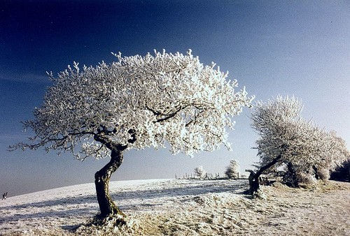
This is a fantastic image of hoarfrost (yes, it's one word) on a tree in Worcestershire. As explained below, hoarfrost is similar to, but not the same as, the more common rime.
Under clear frosty nights in winter soft ice crystals might form on vegetation or any object that has been chilled below freezing point by radiation cooling. This deposit of ice crystals is known as hoarfrost and may sometimes be so thick that it might look like snow. The interlocking ice crystals become attached to branches of trees, leafs, hedgerows and grass blades and are one of the most prominent features of a typical 'winter wonderland' day. However, the fine 'feathers', 'needles' and 'spines' might also be found on any other object that is exposed to supersaturated air below freezing temperature.
Hoarfrost might form as liquid dew that has subsequently frozen with a drop in temperature, which is then known as silver frost or white frost. Usually the dew drops do not freeze immediately, even if the air temperature is slightly below zero. Rather they become supercooled dew droplets at first. Supercooled dew will eventually freeze if the temperature falls below about -3°C to -5°C. Hoarfrost deposits might also derive by sublimation, when water vapour is forming ice directly on the surfaces concerned. In most cases hoarfrost will have formed by a combination of the processes above. (Weather Online)
rime—A white or milky and opaque granular deposit of ice formed by the rapid freezing of supercooled water drops as they impinge upon an exposed object. It is denser and harder than hoarfrost, but lighter, softer, and less transparent than glaze. Rime is composed essentially of discrete ice granules and has densities as low as 0.2–0.3 g cm−3. (American Meteorological Society glossary)
Thursday 7 June 2007
Hoarfrost
Wednesday 6 June 2007
Icey Morning
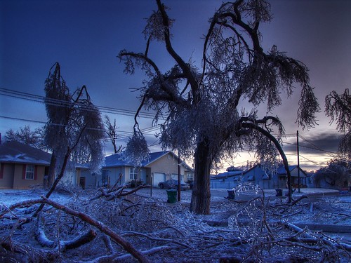
Wow, what a great photo of ice storm damage! We're lucky enough not to have many of them here in Norway, but the east coast Americans all know what this is about.
The Ice storm of 1998 (also known as Ice Storm '98) was a massive ice storm that struck a relatively narrow swath of land from Eastern Ontario to southern Quebec to Nova Scotia in Canada, and bordering areas from Northern New York to Southeast Maine in the United States, in January 1998. It caused massive damage to trees and electrical infrastructure all over the area, leading to widespread long term power outages. Millions were left in the dark for periods varying from days to weeks, leading to more than 30 fatalities, a shut down of activities in large cities like Montreal and Ottawa and an unprecedented reconstruction effort of the power grid. (Wikipedia)
What happens is that supercooled rain hits a cold surface and freezes on contact. Supercooled means that the water temperature is below the freezing point, but the droplets still retain their liquid form.
A liquid below its freezing point will crystallize in the presence of a seed crystal or nucleus around which a crystal structure can form. However, lacking any such nucleus, the liquid phase can be maintained all the way down to the temperature at which crystal homogeneous nucleation occurs. The homogeneous nucleation can occur above the glass transition where the system is an amorphous—that is, non-crystalline—solid. Water has a freezing point of 273.15 K (0 °C or 32 °F) but can be supercooled at standard pressure down to its crystal homogeneous nucleation at almost 231 K (−42.15 °C). (Wikipedia)
At midlatitudes, supercooled rain often forms first as an ice crystal or snow in the clouds, which then melts as it falls through an elevated layer of air warmer than freezing before reaching the thick bottom layer of cold air that cools the drop below freezing. A supercooled drop freezes instantly on contact with surfaces such as electrical power lines, trees, and roads during an ice storm. (American Meteorological Society glossary)
Tuesday 5 June 2007
Weather Factory

This is a terrific example of a dense cumulus cloud. It has the characteristic appearance of a cauliflower and is fuelled by intense updrafts of moist air. As in all clouds, the predominant process is cooling and condensation of the rising air mass. This particular cloud looks like it might develop into a cumulonimbus - a thunderhead, but for now it's just a cumulus congestus.
Cumulus congestus clouds are characteristic of unstable areas of the atmosphere which are undergoing convection. They are often characterized by sharp outlines and great vertical development. Because cumulus congestus is produced by strong updrafts, it is typically taller than it is wide, and cloud tops can reach 5,000 metres (15,000 ft). Cumulus congestus clouds are formed by the development of cumulus mediocris generally, though they can also be formed from altocumulus castellanus or stratocumulus castellanus as well.
Cumulus congestus will mature into cumulonimbus calvus under conditions of sufficient instability. This transformation can be seen by the presence of smooth, fibrous, or striated aspects assumed by the cloud's upper part. This cloud type produces precipitation, often in abundance. The congestus species of cloud can only be found in the genus cumulus. (Wikipedia)
Shine on meeeee!
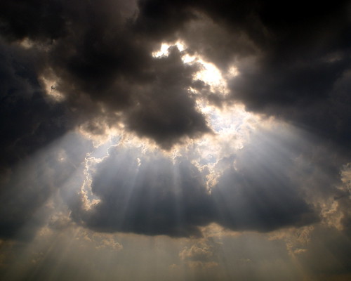
This picture was picked because it's a prime example of crepuscular rays (Jacob's ladder).
Says Wikipedia: Crepuscular rays, in atmospheric optics, also known as sun rays or God's rays, are rays of sunlight that appear to radiate from a single point in the sky. These rays, which stream through gaps in clouds, are diverging columns of sunlit air separated by darker cloud-shadowed regions. The name comes from their frequent occurrences during twilight, when the contrasts between light and dark are the most obvious. Various airborne compounds scatter the sunlight and make these rays visible. The reason we see the light so defined is because of diffraction, reflection and scattering.
Crepuscular rays are near-parallel, but appear to diverge because of linear perspective. They often occur when objects such as mountain peaks or clouds partially shadow the sun's rays like a cloud cover.
Three main forms of crepuscular rays are:
- Rays of light penetrating holes in low clouds (also called "Jacob's Ladder").
- Beams of light diverging from behind a cloud.
- Pale, pinkish or reddish rays that radiate from below the horizon. These are often mistaken for sun pillars.
Polar low

This is a beautiful polar low in the Barents Sea on the 20th of December 2002. ’Polar low’ is the denomination of a wide range of weather phenomena at high latitudes. Although many definitions have been proposed, the following one was given by Rasmussen and Turner in the book "Polar lows" from 2003:
A polar low is a small, but fairly intense maritime cyclone that forms poleward of the main baroclinic zone (the polar front or other major baroclinic zone). The horizontal scale of the polar low is approximately between 200 and 1000 kilometres and surface winds near or above gale force.
A 'baroclinic zone' is a region with large local temperature differences, which are the primary source of 'fuel' for most cyclones outside the tropics ('extratropical cyclones').
Although we now know that polar lows can occur in both hemispheres (a polar low-like feature has even been observed over the Mediterranean), they were first noticed in the Nordic Seas, or more specifically along the coast of Norway.
Read more about polar lows in this article from the Group for Earth Observation (GEO) or on Wikipedia. I wrote my PhD thesis about them.
Prelude to a Storm
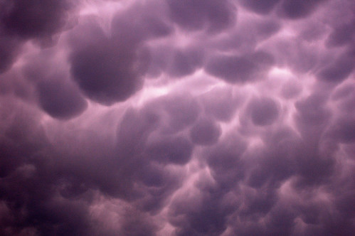
This is a great example of mammatus clouds. They usually form on the 'ceiling' of anvil thunderheads, just where the air is heavy with moisture. Like full breasts, they seem to long to release some of this moisture as precipitation.
From Wikipedia: Mammatus (also known as mamma or mammatocumulus, meaning "breast-cloud") is a meteorological term applied to a cellular pattern of pouches hanging underneath the base of a cloud. The name "mammatus" is derived from the Latin mamma, or breast, due to some persons believing that the clouds bear a significant resemblance to human female breasts.
Mammatus are most often associated with the anvil cloud that extends from a cumulonimbus, but may also be found under altocumulus, altostratus, stratocumulus, and cirrus clouds, as well as contrails and volcanic ash clouds. In the United States, sky gazers may be most familiar with the very distinct and more common cumulonimbus mammatus. When occurring in cumulonimbus, mammatus are often indicative of a particularly strong storm. These tend to form more often during warm months and over the midwest and eastern portions of the country, and more infrequently over the west and southwest. Due to the intensely sheared environment in which mammatus form, aviators are strongly cautioned to avoid cumulonimbus with mammatus.
Mammatus may appear as smooth, ragged or lumpy lobes and may be opaque or semitransparent. Because mammatus occur as a grouping of lobes, the way they clump together can vary from an isolated cluster to a field of mamma that spread over hundreds of kilometers to being organized along a line, and may be composed of unequal- or similarly-sized lobes. The individual mammatus lobe average diameters of 1-3 km and lengths on average of 0.5 km. A lobe can last an average of 10 minutes, but a whole cluster of mamma can range from 15 minutes to a few hours. Their composition is usually mostly ice, but can be a mixture of ice and liquid water or almost entirely liquid water.